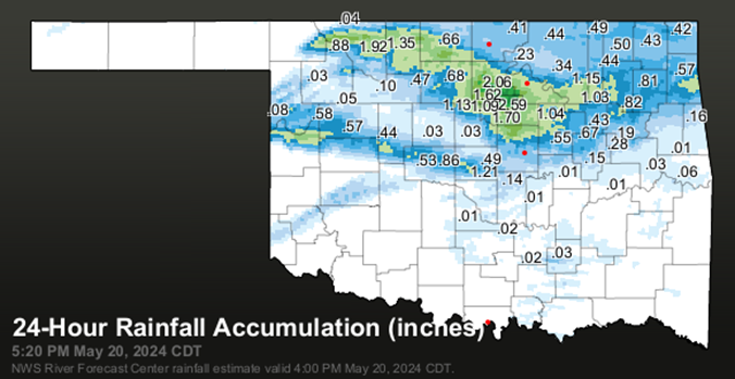
Sunday night turned into a dramatic night of storms as I wondered if I was going to stay on the fringes of the storms with .04" of rain to finding myself not too far from the bullseye of the storms with 3 downpours. When it was over had 2.63" of rain. Far north side of Stillwater had more with just over 3". Northeast of there in Glencoe, a Tempest station has just over 4". Further to the northeast of there, another Tempest station had 4.59" for the most I found. The Oklahoma mesonet rain map below shows gauges aren't widespread enough to catch the specific heaviest rain amounts in the state, though the darkest green spot on the map does correspond where the 4+" amounts were.
Interesting how the severe storms in Kansas had wound down while the storms in north central Oklahoma kept up their intensity. Also, interesting how the tornado bearing OKC storm quickly started dissipating as it entered the neighboring county.
This event was similar to the previous very heavy rain event. Just very heavy rain here with hail and tornados elsewhere. There were eight tornado reports, rated EF1 or EF2. Fortunately, tornadoes didn't go through any towns this time and stayed in rural areas where a few folks lost their homes.
About 4 more weeks to go before the stress of the spring storm season starts transitioning to the more settled summer months.
Val and Amy Castor of Stillwater, who are long time storm chasers for KWTV-9 of OKC, hydroplaned on I-40 in the OKC area and crashed. Fortunately, they were not hurt much. The video as it happened is here:
https://www.news9.com/story/664b69f2b7e0f282d3a9a651/val-castor-shares-update-after-tracking-severe-weather-sunday-night-