There is a flood watch until noon Saturday for more than the northeastern quarter of Oklahoma. It includes Oklahoma City, Tulsa and Stillwater. Tornadoes are possible from south central to east central Oklahoma on Friday. FLOOD WATCH
Areas Affected:
Canadian - Cleveland - Garfield - Grady - Grant - Kay - Kingfisher - Lincoln - Logan - McClain - Noble - Oklahoma - Payne - Pottawatomie - Seminole
Effective: Wed, 4/19 3:45pm Updated: Wed, 4/19 5:51pm Urgency: Future
Expires: Sat, 4/22 12:00am Severity: Moderate Certainty: Possible
Details:
...FLOOD WATCH IN EFFECT FROM LATE THURSDAY NIGHT THROUGH FRIDAY
EVENING...
The National Weather Service in Norman has issued a
* Flood Watch for flash flooding...flooding of creeks and
rivers...and flooding of low lying areas for portions of
central Oklahoma, east central Oklahoma, and northern
Oklahoma, including the following areas, in central Oklahoma,
Canadian, Cleveland, Grady, Kingfisher, Lincoln, Logan,
McClain, Oklahoma, Payne, and Pottawatomie. In east central
Oklahoma, Seminole. In northern Oklahoma, Garfield, Grant,
Kay, and Noble.
* From late Thursday night through Friday evening
* Rainfall totals of 2 to 4 inches within and close to the watch
area. Higher amounts are possible.
Precautionary/preparedness actions...
A Flood Watch means there is a potential for flooding based on
current forecasts. You should monitor later forecasts and be alert for possible
Flood Warnings. Those living in areas prone to flooding should be
prepared to take action should flooding develop.
AREA COVERED:
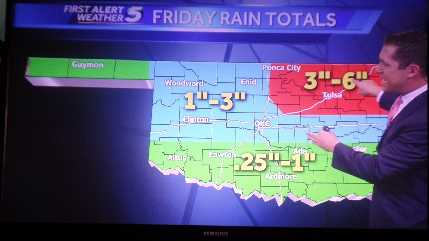
 Weatherman from Oklahoma City TV channel 5 forecasts 3-6" of rain in northeast Oklahoma.