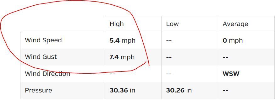
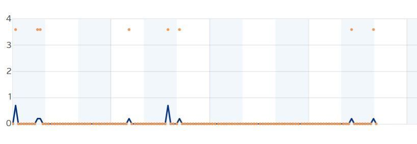
I am wondering if there are any answers and solutions as to why there is a discrepancy between the daily high wind speed/gust and the weather history graph/chart, and how to fix it to reflect a more accurate picture of wind conditions. Today my summary for Feb 28 says the high wind speed was 5.4 mph and gust was 7.4 mph. However when I look at the history chart the highest wind recorded is a mere .7 mph. This discrepancy has been fairly typical for this station. although on windier days the discrepancy is somewhat less.
My theory is that the daily history graph?chart, which appears to record an entry every 5 minutes simply takes whatever the station was reading at that moment whereas the daily high reading is the highest read the station saw, most likely at sometime between those 5 minute interval records. The station itself seems to update every 8 seconds so chances are, unless the unlikely event were to occur where the high wind speed just happened to coincide with the 5 minute interval then the true high speed will never be reflected in the daily history graph.
I think in my situation being a rather gusty place to begin with makes it worse than someplace where there is a lot of sustained wind speeds. However, this for me makes the weather graph/chart paint a very incomplete picture of what the true wind conditions actually are, almost to the point of being worthless. I wish WU would use the actual highest wind speed that occurred within the 5 minute span between updates to the graph instead of whatever the station happened to be reporting at the 5 min interval. I know WU gets this information because I can see the speed being updated every few seconds on rapid fire mode and very often those speeds are far higher than what the graph will show.